
Amidst standoff in Ladakh, China built village in Arunachal Pradesh
DHARAMSALA, 19 Jan: Amid the ongoing border tension between China and India, China has constructed a new village in Arunachal Pradesh, a state in Northeast India.
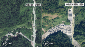
China has constructed a new village in Arunachal Pradesh with as many as 100 houses, media reports said citing the US-based imaging company Planet Labs’ satellite images.
According to reports, the houses have been constructed along the river Tsari Chu in upper Subansiri district in Arunachal Pradesh, the location where no concrete structures were visible in 2019.
The location where over 100 houses have been constructed by the Chinese has been marked by armed conflict owing to the territorial dispute between India and China. The land was occupied by the People’s Liberation Army (PLA) as it overrun an Assam Rifles post in 1959.
The development came at a time of ongoing stand-off in Ladakh between the two Asian giants, with thousands of soldiers from deployed on the frontline at extreme altitudes in sub-zero temperatures by both the party.
Based on satellite images, media reports alleged that the construction of the village at the border took place last year.
New Delhi has responded in affirmative that the administration is aware of China undertaking construction work along with the border areas and that it keeps a strict vigil on all the developments that threaten India’s sovereignty and territorial integrity.
“We have seen recent reports on China undertaking construction work along with the border areas with India. China has undertaken such infrastructure construction activity in the past several years,” India’s the ministry of external affairs has said in a statement.
“In response, our government too has stepped up border infrastructure including the construction of roads, bridges etc, which has provided much-needed connectivity to the local population along the border,” it added.
China claims the entire Arunachal Pradesh as its territory as it calls it ‘South Tibet,’ a claim resolutely rejected by India. Arunachal Pradesh’s Chief Minister Pema Khandu has reiterated on numerous occasion that Arunachal shares boundary with Tibet, not China and that history can’t be erased.
The McMahon Line demarcation is the current effective boundary between China and India after the Chinese occupation of Tibet. It is a demarcation line drawn on the map referred to in the Shimla Accord, a treaty signed between Britain and Tibet in 1914.