
China may be installing new radar on South China Sea outposts: Think tank
Reuters | February 23, 2016
WASHINGTON – Recent satellite images show China may be installing a high-frequency radar system in the Spratly Islands that could significantly boost its ability control the disputed South China Sea, a U.S. think tank reported on Monday.
The Asian Maritime Transparency Initiative at Washington’s Center for Strategic and International Studies said the images showed that construction of facilities at Cuarteron Reef appeared nearly complete and that the artificial island now covered an area of about 52 acres (210,500 square meters). “Two probable radar towers have been built on the northern portion of the feature, and a number of 65-foot (20-meter) poles have been erected across a large section of the southern portion,” the report said.
“These poles could be a high-frequency radar installation, which would significantly bolster China’s ability to monitor surface and air traffic across the southern portion of the South China Sea.”
China’s foreign and defense ministries did not immediately respond to requests for comment.

The report said the images showed that China appeared to have constructed a buried bunker and lighthouse on the northern portion of the feature, a helipad, communications equipment and a quay with a loading crane.
The report, which based its analysis on satellite images from January and February, said China already had significant radar coverage of the northern part of the South China Sea given its mainland installations and in the Paracel Islands to the northwest of the Spratlys.
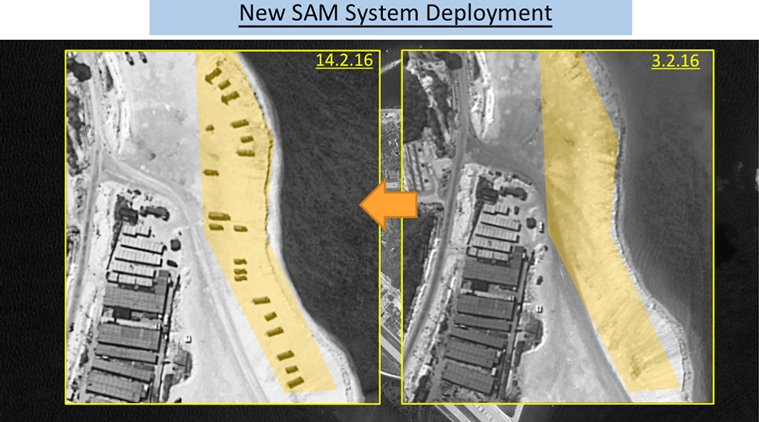
Both the U.S. and Vietnam last week expressed concern at China’s deployment of advanced surface-to-air missiles on the Paracels.
A high frequency radar on Cuarteron Reef would increase China’s ability to monitor sea and air traffic coming north from the Malacca Straits and other important channels, the report said.
It also pointed to “probable” radars at Gaven, Hughes and Johnson South Reefs in the Spratlys as well as helipads, and to possible gun emplacements at the former two features.
China previously operated radars on Fiery Cross but the latest installations would give it far more extensive coverage, regional military analysts said.
The report comes a day before a visit to the United States by China’s Foreign Minister Wang Yi, at which U.S. concerns about China’s assertive territorial claims will be high on the agenda.
China’s Foreign Ministry said its military deployments in the South China Sea were no different from U.S. deployments on Hawaii.
U.S. State Department spokesman Mark Toner said Washington would “press China to de-escalate and stop its militarization” in the South China Sea.
China claims most of the South China Sea, through which more than $5 trillion in global trade passes every year. Vietnam, Malaysia, Brunei, the Philippines and Taiwan have rival claims.