India Calls China’s Renaming of Arunachal Sites “Baseless and Mischievous”
By Tenzin Chokyi
DHARAMSALA, 14 April: India has categorically rejected China’s latest issuance of “standardised names” for geographical locations in its northeastern state of Arunachal Pradesh(AP), calling them “mischievous attempts” and an effort at “introducing false claims and manufacturing baseless narratives,” which, it said, would not alter the fact that the state is an integral part of India.
India “categorically rejects any mischievous attempts by the Chinese side to assign fictitious names to places which form part of the territory of India,” Ministry of External Affairs (MEA) spokesperson Randhir Jaiswal said on Sunday.
“Such attempts by China at introducing false claims and manufacturing baseless narratives cannot alter the undeniable reality that these places and territories, including AP, were, are, and will always remain an integral and inalienable part of India,” he said, according to multiple reports.
Jaiswal has further emphasised that China should refrain from actions that inject negativity into bilateral relations and undermine efforts to improve understanding, noting that such steps “detract from ongoing efforts to stabilise and normalise India-China bilateral ties.”
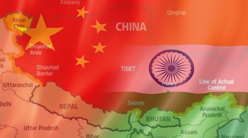
The ministry’s response came after China’s Ministry of Civil Affairs on 10 April announced “standardised names” for 23 locations in AP, claiming it as “south Tibet”. As with the previous list, each entry is provided in Chinese characters, Tibetan script and Pinyin.
China’s claim over India’s AP as “South Tibet” under its designation “Zangnam” is viewed by some Tibetan scholars as a reinterpretation of Tibet’s historical relationship with Monyul (a Tibetan term for lowlands) in present-day AP, and as part of a broader narrative manipulation used by China in the ongoing border dispute with India.
Dr Tsewang Dorji, a senior researcher at the Tibet Policy Institute (TPI), a think tank under the Central Tibetan Administration, who focuses on “Tibet and the Himalaya,” said that many of the “standardised names” issued by Chinese authorities have historically been used by Tibetan and Monpa communities in the region, and continue to be used locally today.
He added that the territorial dispute between India and China today can be traced back to the 1914 Simla Convention, under which territories including Monyul were recognised as part of British India by the then Gaden Phodrang government of Tibet, leading to the establishment of the McMahon Line.
China, however, has rejected the legitimacy of the agreement since the 1950s, arguing that Tibet is part of China and that the Tibetan government did not possess the sovereignty to sign treaties, and therefore had no legal standing under international law.
Dorji said this interpretation is a historical distortion, and that China’s present position is shaped by its assertion that Tibet forms an integral part of its territory. He added that the Sino-Indian border dispute emerged after Tibet ceased to function as a buffer zone between the two countries following its occupation by the People’s Republic of China.
He noted that by controlling Tibet, China attempts to assert its claim over Monyul and the broader Himalayan region, and that Chinese strategic thinking has at times described Tibet as a “palm,” with Ladakh, Nepal, Sikkim, Bhutan and Arunachal Pradesh conceptualised as the “five fingers,” reflecting what critics describe as an expansionist geopolitical imagination.